Alexandria is planned as 18 small areas in six ZIP codes, all zoned for one high school. Zillow's typical city value was $662,843 in September 2026.
Last checked Oct. 19, 2026. The areas on this page are the City of Alexandria’s own small plan areas, from its Small Area Plans map layer. School zones come from Alexandria City Public Schools’ 2026-27 Attendance Zone Locator; ZIP codes from the Census Bureau’s ZIP Code Tabulation Areas; home values from the Zillow Home Value Index (Zillow Research); place names from OpenStreetMap (© OpenStreetMap contributors); population from the Census Bureau’s QuickFacts.
Alexandria is an independent city of 156,976 people on about 15 square miles, part of no county. The city divides itself into 18 small plan areas, each with its own adopted plan for land use and growth. Most homes are in six ZIP codes, every public school student is zoned for the same high school, and the elementary and middle school depend on the address. This guide maps the areas and links a full guide for 12 of them.
What this means for you
- High school for every city address: Alexandria City High School
- Typical home value, city: $662,843 in September 2026, according to Zillow
- Interstates: I-395 runs along the west side; the Capital Beltway (I-95 and I-495) crosses the south end to the Woodrow Wilson Bridge
- Zone questions: ACPS, 703-619-8000
How the city is laid out
- City limits matter more than the mailing address. ZIP codes 22303, 22306, 22310 and 22315 carry Alexandria addresses but Zillow files them under Fairfax County, and 22312 is mostly in Fairfax County too. Places such as Huntington, Rose Hill and Lincolnia are Fairfax County communities. A home there pays Fairfax County taxes and goes to Fairfax County Public Schools. The city’s real estate search lists only city parcels.
- The main roads: I-395 (the Henry G. Shirley Memorial Highway) on the west, with exits 3 to 7 serving the city; the Capital Beltway, with exits 173 to 177 serving the city, across the south; Richmond Highway (U.S. 1) and the George Washington Memorial Parkway on the east; King Street (Route 7) and Duke Street (Route 236) east to west.
- School zones do not follow plan area lines. Under the 2026-27 boundaries, Seminary Hill alone is split among five elementary zones, and Del Ray and Arlandria among four each.
- Metrorail has five stations in the city: Braddock Road, King Street-Old Town, Eisenhower Avenue, Van Dorn Street and Potomac Yard. DASH city buses are fare-free; see our getting around guide.
Map of the plan areas
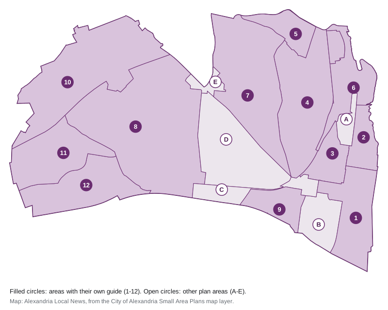
Map: Alexandria Local News, drawn from the City of Alexandria’s Small Area Plans map layer.
The areas at a glance
Values are Zillow’s Home Value Index for the ZIP code that covers most of each area, in September 2026. A ZIP code is much larger than a plan area, so treat it as a broad guide. Every row is zoned for Alexandria City High School.
| # | Area | Main ZIP | Main elementary zone (share) | High school | Typical value in its ZIP | Guide |
|---|---|---|---|---|---|---|
| 1 | Old Town | 22314 | Lyles-Crouch 98% | Alexandria City High | $866,449 | Old Town |
| 2 | Old Town North | 22314 | Jefferson-Houston 90% | Alexandria City High | $866,449 | Old Town North |
| 3 | Braddock Road Metro | 22314 | Jefferson-Houston 75% | Alexandria City High | $866,449 | Braddock Road |
| 4 | Potomac West (Del Ray) | 22301 | Mount Vernon 54% | Alexandria City High | $1,062,804 | Del Ray |
| 5 | Arlandria-Chirilagua | 22305 | Cora Kelly 57% | Alexandria City High | $805,548 | Arlandria |
| 6 | Potomac Yard | 22314 | Jefferson-Houston 93% | Alexandria City High | $866,449 | Potomac Yard |
| 7 | North Ridge/Rosemont | 22302 | George Mason 46% | Alexandria City High | $422,471 | North Ridge and Rosemont |
| 8 | Seminary Hill/Strawberry Hill | 22304 | Douglas MacArthur 51% | Alexandria City High | $440,940 | Seminary Hill |
| 9 | Eisenhower East (Carlyle) | 22314 | Lyles-Crouch 100% | Alexandria City High | $866,449 | Eisenhower East |
| 10 | AlexWest | 22311 | John Adams 47% | Alexandria City High | $691,732 | Alexandria West |
| 11 | Landmark/Van Dorn | 22304 | James K. Polk 40% | Alexandria City High | $440,940 | Landmark and Van Dorn |
| 12 | Eisenhower West (Cameron Station) | 22304 | Samuel W. Tucker 98% | Alexandria City High | $440,940 | Cameron Station |
| A | Northeast | 22314 | Jefferson-Houston 100% | Alexandria City High | $866,449 | Below |
| B | Southwest Quadrant | 22314 | Lyles-Crouch 100% | Alexandria City High | $866,449 | Below |
| C | King Street Metro/Eisenhower Avenue | 22314 | Lyles-Crouch 92% | Alexandria City High | $866,449 | Below |
| D | Taylor Run/Duke Street | 22314 | Douglas MacArthur 100% | Alexandria City High | $866,449 | Below |
| E | Fairlington/Bradlee | 22302 | Charles Barrett 55% | Alexandria City High | $422,471 | Below |
Zillow’s figure for 22314 was up 3.7% on the year, 22301 up 3.6%, 22305 up 2.8%, 22311 up 0.8%, 22304 down 0.9% and 22302 down 1.9%. The citywide figure was up 1.0%. The index is a modeled typical value for mid-priced homes, not a sale price; our home prices guide has the trend.
The areas with their own guide
- Old Town: the 551-acre riverfront plan area from Oronoco Street to Jones Point, with City Hall, Market Square and the waterfront parks.
- Old Town North: 222 acres on the river north of Oronoco Street, including the former power plant site the city plans as an innovation district.
- Braddock Road Metro: the grid around Braddock Road station, including the Parker-Gray Historic District.
- Del Ray: the heart of the Potomac West plan area, with Warwick Village, Lynhaven, St. Elmo and part of Rosemont, along Mount Vernon Avenue.
- Arlandria: 230 acres on Four Mile Run at the Arlington line, with its own plan since 2022.
- Potomac Yard: the former rail yard between U.S. 1 and the parkway, with Potomac Greens, North Potomac Yard and its own Metro station.
- North Ridge and Rosemont: 1,118 acres north of King Street, including Beverley Hills, Jefferson Park and Parkfairfax.
- Seminary Hill: 1,888 acres between I-395 and Quaker Lane, with Fort Ward Park and Francis C. Hammond Middle.
- Eisenhower East: Carlyle and the blocks around Eisenhower Avenue station.
- Alexandria West: the AlexWest plan area along Beauregard Street, west of I-395, including the Mark Center.
- Landmark and Van Dorn: the West End around Duke Street and the former Landmark Mall.
- Cameron Station and Eisenhower West: the southwest corner around Van Dorn Street station.
The other plan areas
- Northeast (95 acres): between Old Town North, Potomac Yard and the Braddock Road Metro area, along the George Washington Memorial Parkway and Slaters Lane. Zoned for Jefferson-Houston.
- Southwest Quadrant (285 acres): south of Duke Street between South Washington Street and Hooff’s Run, reaching the Capital Beltway. Zoned for Lyles-Crouch and George Washington Middle.
- King Street Metro/Eisenhower Avenue (211 acres): the blocks around King Street-Old Town station and Union Station. Mostly zoned for Lyles-Crouch.
- Taylor Run/Duke Street (799 acres): south of King Street between the rail lines and Quaker Lane, including Chinquapin Park, the King Street campus of Alexandria City High and places OpenStreetMap names Clover, College Park, Chapel Hill and Cameron Valley. Zoned for Douglas MacArthur Elementary and George Washington Middle; split between ZIP codes 22314 and 22302.
- Fairlington/Bradlee (69 acres): the shopping center corner at King Street and Quaker Lane, with Safeway, The Fresh Market and Walgreens. Split between the Charles Barrett and George Mason zones.
Comparing Alexandria with its neighbors
For tax rates, schools, home values and services in Arlington, Fairfax County and Falls Church, see Alexandria vs Arlington vs Fairfax County vs Falls Church. Our schools guide has the ACPS calendar and ratings, and our property tax guide has the city rate.
How we built this
The areas are the City of Alexandria’s 18 adopted small area plans as drawn on its planning map; we merged Potomac Yard/Potomac Greens and North Potomac Yard into one guide. We matched each area to ZIP codes using the Census Bureau’s ZIP Code Tabulation Areas and to school zones using the ACPS 2026-27 zone layer, measuring the share of each area’s land in each zone. Neighborhood names inside the areas come from the plans themselves and from OpenStreetMap. We did not name individual subdivisions, rank areas or describe who lives in them. Road distances on each guide come from OSRM routing on OpenStreetMap data.
Frequently asked questions
What are the neighborhoods of Alexandria, Virginia?
The city plans itself as 18 small plan areas, including Old Town, Old Town North, Potomac West (Del Ray), Arlandria-Chirilagua, Potomac Yard, North Ridge/Rosemont, Seminary Hill/Strawberry Hill, Eisenhower East (Carlyle), AlexWest, Landmark/Van Dorn and Eisenhower West (Cameron Station).
What ZIP codes are in Alexandria, Virginia?
The city is mostly in 22301, 22302, 22304, 22305, 22311 and 22314. Several other ZIP codes with Alexandria mailing addresses, such as 22303, 22306, 22310 and 22315, are mostly in Fairfax County, so a mailing address does not prove a home is in the city.
Do all Alexandria neighborhoods go to the same high school?
Yes. Every city address is zoned for Alexandria City High School. Elementary and middle school zones differ, and new ACPS boundaries took effect with the 2026-27 school year.
What is the typical home value in Alexandria?
Zillow’s Home Value Index put the city at $662,843 in September 2026. By ZIP code it ranged from $422,471 in 22302 to $1,062,804 in 22301. These are modeled values, not sale prices.
Have your say